Facilities managers at the U.S. Department of Energy’s Lawrence Livermore National Laboratory (LLNL) have adopted an underground utility marking system to improve work efficiency and protect high-value operations. Since its founding in 1952 in a remote area east of the San Francisco Bay, the lab has become a leading scientific center for a number of technologies including energy, biomedicine, homeland security and environmental science.
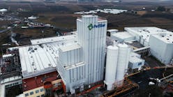
Bruce Fritschy, LLNL damage prevention manager, notes the Livermore, Calif., operation consists of a one square-mile campus on the premises of a former naval air station.
“Livermore Labs has all of the infrastructure complexities of a municipality as well as specialized science-related facilities,” he said. “Our unique buried pipe network includes supply and return for low conductivity (process) water, conventional city water and deionized water, as well as sanitary sewer and storm drains, and special waste disposal systems. Of course, we also have buried telecommunications, natural gas, and low- and high-voltage electrical power, along with compressed air and piping for various gases used in lab operations.”
The multiplicity of conventional and specialized underground facilities means a locate project can entail as many as 13 separate utilities on a single ticket, and workers also must contend with abandoned or unknown underground components as well as concrete runway remnants. Fritschy stresses that facilities management at this location is far more complex than typical public works activity - and effective underground mapping and locating methods are essential.
For reasons of safety and the critical status of laboratory work, LLNL has a zero tolerance for damage to underground facilities, the damage prevention manager explains. Underground utility work on the campus is managed by the LLNL Technical Administration Group, located within Plant Engineering’s Facilities Maintenance Management Division. The group follows tight operating procedures for installation and maintenance of underground facilities, both within buildings and across the campus. It enforces a 30-inch dig restriction zone around buried facilities, which exceeds state requirements by six inches.
“In past years, underground locating on the LLNL campus was done by outside contractors, and there were instances of unacceptable damage because of locator inaccuracies and poor record keeping,” Fritschy said. “Consequently, we instituted a program of in-house locating and centralized record-keeping, along with a permit procedure based on the national One-Call System and the U.S. Department of Transportation’s one-call study, along with some enhancements to meet internal needs. Today, we follow a Safety Through Damage Prevention program that includes a One-Call Permit system to administer five different permit categories for LLNL locating projects.”
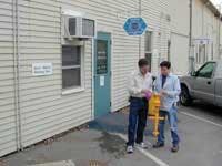
Fritschy said outside contractors still do some locating assignments, but vendors must be on an LLNL-approved list. Both contract individuals and the five LLNL staff locators must be fully trained and third-party certified before they’re allowed to handle locates.
Some time ago, the LLNL organization took on the task of videotaping and mapping the underground pipe network, including all sewer and drain facilities on campus. This condition assessment provided an accurate record of underground conditions to help with planning repair and replacement work. The sewer and drain survey and repair program took five years and resulted in a greatly improved ability to deal with major spills and other eventualities, Fritschy added.
In the late 1990s, the damage prevention staff began to use passive underground markers to pinpoint locations of specific utility components. Markers were buried during construction operations or when crews were trenching for repair or system upgrades, and these marked points were incorporated into LLNL plant records. Fritschy said while passive markers enable locators to return to a specific point later, they provided no details about the buried environment, particularly when details hadn’t been properly recorded on campus records.
This deficiency was rectified at the beginning of 2003 when LLNL adopted the new 3M Dynatel 2200MiD Series Locating and Marking System, which uses active markers.
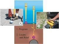
“Active markers placed in the field have unique, preset ID numbers, and are programmed with pertinent data by the working crew at time of placement,” said Fritschy.
“These details include which utility or utilities are present, how deep the infrastructure lies, the associated permit number, a locator grid point on the campus map, and the date of placement. With active marking, a crew can return at a later time, find the marker quickly, verify details, and then dig with confidence. Workers now know in advance what to expect, whether it’s a water line, a sewer line stub, gas valve, specialty gas line, as well as other useful information.”
The entire underground infrastructure is mapped in detail, and buried pipe features in the field, such as valves, stubs, Ts and pipe turns are indicated by active ID markers. A pipeline straightaway can be easily marked by tracing a line between marker locations, making it easy to dig directly down to the pipe at any point.
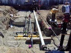
In municipalities, crews generally use active markers of different colors for each utility, per industry standards, and each marker color has its own locator frequency. But LLNL managers decided to standardize on general purpose purple 3M 1400 Series EMS iD ball markers for all facilities throughout the complex so crews can find and read any marker quickly, using a single marker ball frequency on the locator. In some places, Fritschy said, multiple markers indicate presence of multiple utility features in close proximity. Details can be sorted out by merely reading the on-screen response from each marker.
LLNL maintains an Open Trench Policy, which requires all excavation work begin with a permit defining the intended locate. When a trench has been excavated the Permit Office (or One Call Center) is notified the utility has been exposed so any new or existing utility location data can be captured and duly recorded. A site survey spots the location on the LLNL grid, and a marker ball is programmed and placed before backfilling.
Crews generally also take a digital photo of the exposed utility for campus records, and then a compliance coordinator verifies the process. Consequently, the next time a crew is sent to that location, they’ll know in advance what will be found, based on multiple resources including the programmed marker, office documentation and the photographic record. Fritschy anticipates this process will improve both worker safety and efficiency of underground facilities management.
Work at the LLNL campus is routinely audited by the Department of Energy to verify the accuracy of configuration management and infrastructure mapping. Since Fritschy estimates an average of 850 locates are done each year by in-house and contract locators, that makes coordination on his end all the more crucial. The complexity of the campus infrastructure and zero tolerance for damage means a typical locate can take as much as four or five hours.
“We’re currently supplementing marker data with a Global Positioning System (GPS) capability,” said Fritschy. “This will further complement our open trench program, and help us confirm the accuracy of campus maps. We plan to collect global coordinates for each ball maker and add this data to spreadsheet records and CAD drawings of the site. The process will coordinate an on-site transmitter signal with satellite information to yield a field positioning capability with centimeter accuracy. We expect in the future our locators will use GPS equipment to reach a marker, and then read and collect data with a marker locator. The 3M marker locator can be equipped with software that allows it to work seamlessly with GPS units and data.”
Conclusion
According to Fritschy, accurate marking and error-free location work is of overriding importance for LLNL. An internal audit showed the paperwork and documentation expense required in response to a damage event could well be in excess of $100,000, with damage repair and safety losses. And disruption to critical laboratory activities would represent added costs. Thus, use of active markers and adoption of strict locating standards along and accurate record-keeping represent a clear value for Lawrence Livermore National Laboratories. IWW
About the Author:
Corey Willson is a product manager for marking and locating products with 3M Communication Markets Division. He has over 20 years of industry experience and works with underground marking applications across the full utility infrastructure. Contact: 512-984-1562, [email protected] or www.3m.com/dynatel
